
Prabesh Tamang
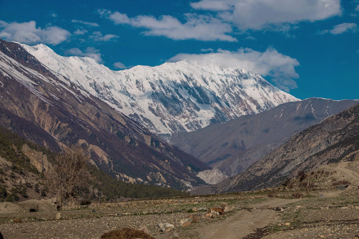
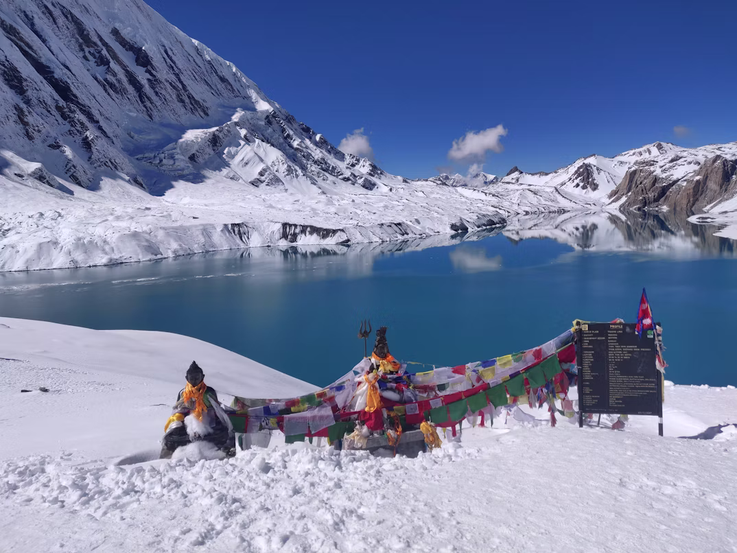
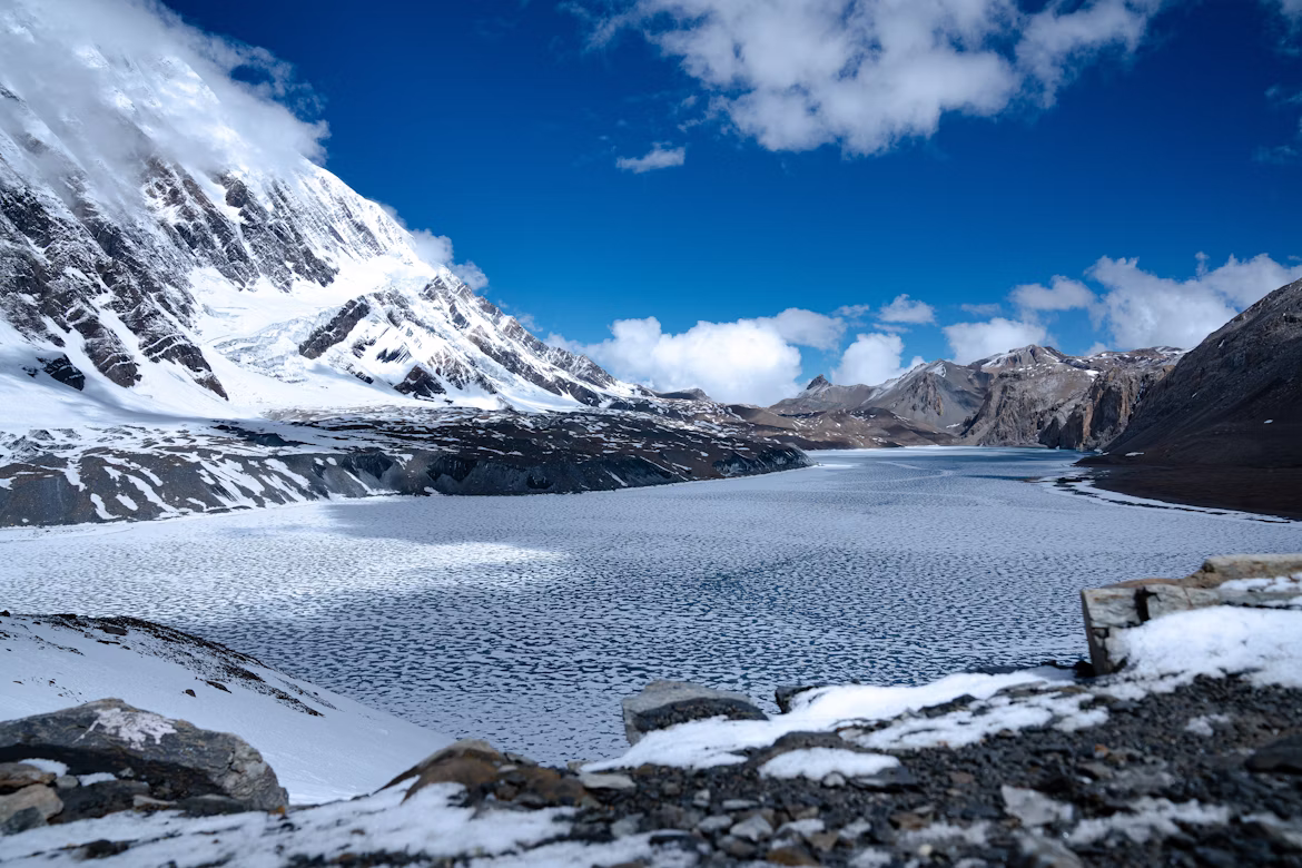
Standing at the edge of Tilicho Lake at 4,919 meters, watching the wind carve patterns across turquoise water flanked by the Tilicho Peak ice wall, this is the payoff for one of the most demanding side trips in the entire Annapurna region. Tilicho Lake is widely considered one of Nepal's most visually dramatic alpine destinations in Nepal, and for good reason. The lake holds a sacred place in Hindu mythology, locally associated in Hindu tradition with the legendary Kak Bhusundi Lake described in ancient texts.
This guide reflects current trekking practices, permit structures, and logistical conditions commonly reported for the 2025-2026 trekking seasons. Whether you're tackling Tilicho as a standalone trek or stitching it into the full Annapurna Circuit, the details below will save you time, money, and altitude-related grief.

Source: Alexis Rodriguez
Panoramic view of Tilicho Lake completely frozen over with patterned ice during winter in the Manang district.
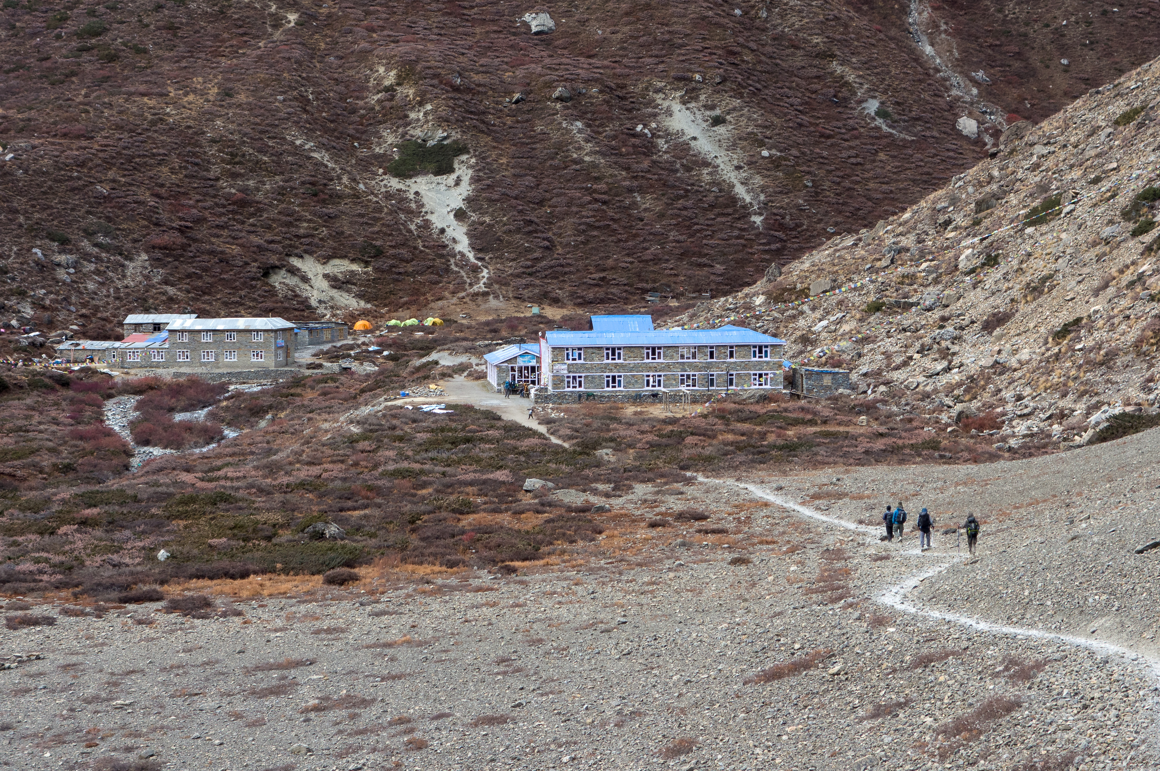
The Tilicho Lake Trek is a 10-14 day high-altitude journey through the Manang district of the Annapurna Conservation Area, culminating at a glacial lake perched at 4,919 meters. The route demands solid acclimatization and is most commonly completed with a licensed local guide, and tolerance for landslide-prone scree sections between Khangsar village and Tilicho Base Camp.
The ultimate guide to planning your dream web travel adventure with the experts from myeasyguide.
Spam free. Unsubscribe anytime. We respect your privacy.

Source: Kabi Acharya
A rugged mountain trekking path offering views of towering snow-capped peaks in the high-altitude trans-Himalayan region leading to lake tilicho.
The Tilicho Lake route falls inside the Annapurna Conservation Area. Trekkers are generally expected to carry an ACAP permit at NPR 3,000 per foreign trekker, while TIMS requirements continue to vary depending on operator practices and checkpoint enforcement. The e-TIMS card at NPR 2,000 for organized trekkers (NPR 1,000 for SAARC nationals). Both are issued at the Nepal Tourism Board offices in Kathmandu or Pokhara.
Since April 2023, Nepal's current trekking framework strongly encourages foreign trekkers in the Annapurna region to travel with a licensed guide arranged through a registered agency. You must hire a licensed guide registered through a government-approved trekking agency. Our marketplace verifies every guide's license number, insurance status, and prior route experience on the Tilicho approach specifically, this trail has too many objective hazards for a generalist.
Standard travel insurance will not cover you here. You need a policy that explicitly includes high-altitude helicopter evacuation up to 5,000 meters and medical treatment for AMS, HAPE, and HACE. Carry both digital and printed copies, most reputable trekking agencies now request proof of high-altitude evacuation coverage before departure.
This itinerary respects the 300-500 meter sleep elevation rule above 3,000 meters and builds in two acclimatization days. Skipping these days is the single most common mistake we see on Tilicho, and the reason for most evacuations.
Road expansion has changed parts of the lower Annapurna experience in recent years, but the Tilicho side route still retains a far more remote and alpine character than the jeep-access sections below Manang.

Source: Wikimedia Commons
Remote stone tea houses and lodges at Tilicho Base Camp along the Annapurna Circuit trekking trail.
The most objectively hazardous section of the trek is the 6-7 hour traverse from Khangsar to Tilicho Base Camp. The trail crosses an active landslide zone where loose scree slopes drop hundreds of meters into the Marsyangdi valley below. There is a newer upper trail that bypasses some of the worst sections, but it requires extra elevation gain.
Our guides start this section before 7:00 AM when freeze-thaw rockfall activity is typically lower. By afternoon, sun-loosened debris regularly tumbles across the path. Trekking poles are non-negotiable here, and we recommend particularly cautious trekkers sometimes choose to wear lightweight climbing helmets through active rockfall sections.
Tilicho Base Camp consists of a small cluster of basic lodges with dormitory-style rooms. During peak season (October especially), beds can fill surprisingly early during peak October trekking weeks, arrive early or risk sleeping on dining room benches. Lodges here charge NPR 500-700 for hot showers (gas-heated), NPR 300-500 to charge electronics, and NPR 400-600 for Wi-Fi access. Carry sufficient Nepalese Rupees in cash, there is no ATM past Chame.

Source: Sanjay Hona
Vibrant turquoise waters of Tilicho Lake with Buddhist prayer flags and snowy Annapurna Himalayan peaks.
The walk from Tilicho Base Camp to the lake is a 3-4 hour ascent gaining roughly 770 vertical meters. Most groups depart by headlamp at 4:00-5:00 AM to reach the lake before the afternoon winds turn savage. The trail switchbacks up a moraine ridge, then traverses a long, exposed plateau where wind chill can create severe wind chill conditions even during otherwise clear autumn weather.
The first view of Tilicho Lake stops most trekkers cold. The water shifts color through the day, milky pale blue in morning shadow, deep turquoise by midday, slate-grey when clouds roll in from Tilicho Peak. Tilicho Peak (7,134 m) and Khangsar Kang dominate the horizon to the north.
Most groups spend limited time at the lake before descending due to altitude exposure, wind, and rapidly changing weather at the lake itself. The altitude is no joke, weather flips fast, and you still have a long descent back to Base Camp. Some experienced groups do a brief touch on the lake's eastern shoreline; we strongly advise against attempting to circumnavigate or swim, both are generally discouraged due to safety risks, freezing temperatures, and the lake's spiritual significance.
Note that Upper Mustang, just across the Thorong La, sits in the Himalayan rain shadow and remains trekkable through monsoon, a useful piece of intel if you're combining regions.
Above 3,000 meters, your sleep elevation should not increase by more than 300-500 meters per day. Tilicho's altitude profile is sneaky: Base Camp at 4,150 m feels manageable, but the lake itself at 4,919 m hits hard. Many trekkers descend with mild AMS symptoms (headache, nausea, poor sleep) after lake day.
The acclimatization day in Manang is considered essential for safe ascent. Use it for a hike up to Ice Lake (4,600 m) or the Gangapurna viewpoint, climbing high and sleeping low is the single best altitude prep available. The Himalayan Rescue Association runs a daily altitude awareness talk in Manang at 3:00 PM; attend it.
Persistent headache that doesn't respond to ibuprofen, loss of coordination, dry cough at night, or any confusion are immediate descent triggers. HAPE and HACE kill quickly at these elevations. Your guide should carry a pulse oximeter and check readings each evening, Experienced guides assess pulse oximeter trends alongside symptoms, hydration, walking pace, appetite, and coordination rather than relying on a single oxygen saturation reading.
Eat vegetarian on this trek. Meat at Manang, Khangsar, and Base Camp is carried up by mule over multiple days without refrigeration, food handling and refrigeration become increasingly unreliable at higher elevations. Stick with Dal Bhat (lentils, rice, vegetable curry), which comes with free refills and provides sustained energy for high-altitude exertion.
Do not buy plastic bottled water. The Annapurna Conservation Area Project actively discourages it, and prices climb to NPR 300-400 per liter at Base Camp anyway. Carry a reusable bottle paired with a UV purifier (Steripen), Sawyer Squeeze filter, or chlorine dioxide drops. Refill stations exist at most lodges for NPR 50-100 per liter.
The Manang region is deeply Tibetan Buddhist. As you walk through villages like Pisang, Ghyaru, Braga, and Manang, you'll pass countless mani stones, chortens, and prayer wheels. Always pass these on the left side (keeping them to your right), and walk clockwise around any stupa or monastery.
The Braga Monastery, perched above the trail between Pisang and Manang, dates back over 900 years and is worth a visit. Remove shoes and hats before entering, and never photograph the prayer hall interior unless a resident monk gives explicit permission.
Verify domestic flight and private jeep rates directly through your agency, as these prices fluctuate with fuel costs and seasonal demand.
Tipping is culturally expected and forms a vital part of guide and porter income. The marketplace standard is 15%-20% of your total trek cost, distributed among the crew. Present tips on the final evening in clean envelopes, with the larger share going to your lead guide.
Ncell generally provides the most reliable mobile coverage through much of the Annapurna Circuit, including Manang and even patches near Tilicho Base Camp on clear days. Pick up an Ncell tourist SIM at Kathmandu or Pokhara before departure, passport required. Nepal Telecom (NTC) works as a secondary option.
Yes. You can trek Tilicho as an out-and-back from Manang, returning the same way through Chame to Besisahar. This shorter version takes 9-10 days and skips the Thorong La crossing entirely.
No. The lake partially freezes from December through March but thaws completely in summer. Even in autumn, the surface remains liquid though brutally cold, tnear freezing temperatures.
You should be able to hike 6-8 hours daily on consecutive days carrying a light daypack. Prior multi-day trekking experience helps significantly. Cardio training three months ahead of departure is the minimum we recommend.
Reliable ATM access becomes extremely limited beyond Besisahar and lower Annapurna towns. Carry sufficient Nepalese Rupees in cash before heading deeper into the Manang region.
Sudden heavy snow or active landslides occasionally close the Khangsar-Base Camp section. Your guide will assess conditions daily and may recommend turning back. Build 1-2 buffer days into your overall itinerary for this scenario.
Absolutely, this is the one of the classic extended Annapurna high-altitude itineraries. After Tilicho, traverse to Yak Kharka via a high route, then continue to Thorong Phedi and over the 5,416-meter pass to Muktinath. Plan 14-16 days total.